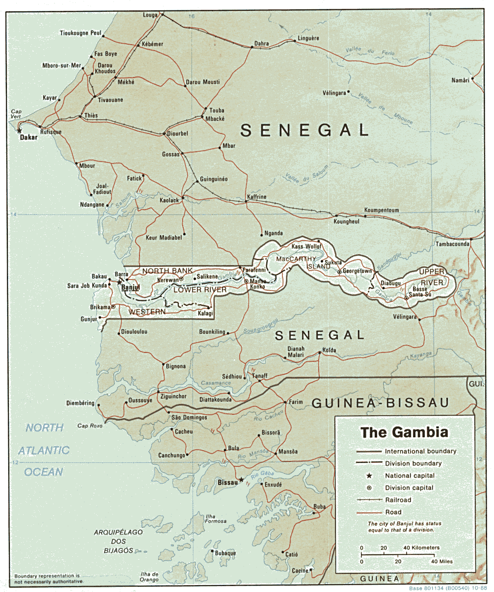
I got lots of responses to this puzzle, and many involved some quite interesting little corners of the world, where tendrils of one country snake a long distance into another. Nonetheless, I’ve come to think (together with reader Rich Rostrom, who also recommended this) that for the puzzle to be especially esthetically pleasing — an obviously highly subjective judgment — we have to somehow eliminate the micro-concavities, such as the ones shown on this Brunei map (thanks to Julia Bauder), the ones on this Tajikistan map (thanks to Kenneth Hahn), or the ones that Heinrich Foltz noted as to a portion of the Ireland / Northern Ireland border. So I suggest that the requirement be that the two points be at least 15 miles apart by the short route, which includes my favorite answer (Gambia as a concavity inside Senegal) but excludes the tiny ones. Here’s Rich Rostrom’s take on this:
There are little tiny wiggles in some national borders that have very high base-to-depth ratios, but they’re tiny: horseshoe bends in rivers, and such. If these were allowed, the contest would in effect be for the narrowest base, something hard to determine off maps of any but the largest scale. (Some of these mini-bulges are less than a km across at the base.)
On the large scale, Senegal/Gambia is a good candidate. Using this map I arrived at a ratio of 16.5. (The base is at the inside corner where the southern border jogs north.)
I looked at some other African boundaries:
Malawi and Mozambique (with the base cutting across Lake Nyasa) [and] Congo and Zambia[, but] they came in rather lower (6.68 and 8.09).
I looked at India/Bangladesh (West Bengal to Tripura). The base is wide, and the ratio is only 4.70.
I considered the intricate mess that Stalin made of central Asia, between Kyrgyzstan, Tajikstan, and Uzbekistan. But it appears that all the protrusions have fairly wide bases.
At a smaller scale, I considered Brunei-Malaysia. Brunei consists of two enclaves on the west and south sides of Brunei Bay, with a short stretch of Malaysian coast between. The eastern enclave is long and narrow, for a ratio of 8.72.
There is a protrusion of Lithuania into Belarus, SSE of Vilnius. This hernia-like blob is 5 km at the neck and 61 km around, for a respectable ratio of 12.2, but still well below Senegal/Gambia.
Another small scale candidate was Switzerland and Germany (the Schaffhausen canton north of the Rhine.) Schaffhausen has a nice mushroom shape, but the base seems narrower than it is, due to a German enclave there; the ratio is only 5.83.
However, the western lobe of Schaffhausen comes near a north-of-the-Rhine extension of Zurich canton, with a wedge of Germany between. The gap at the base of the wedge is only 1.3 km across, yet to get from the Swiss territory north of the gap to the Swiss territory south of the gap, travelling through Switzerland only, one must go 33.6 km, for a ratio of 25.9.
I think that may be the record. Though it does approach the smallest-possible-base type of concavity. [This] shows the neck. [This] shows the region.
Somehow this doesn’t seem like what you’re looking for, though. . . .
Comments are closed.