
|
 |
Alexander "Sasha" Volokh
My tour of medieval Europe
Dover, England, July 2, 1999
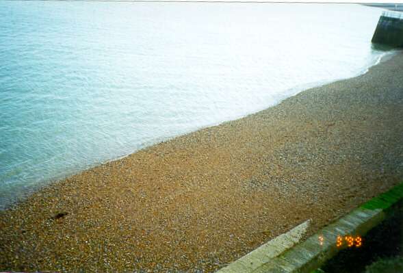
Listen! you hear the grating roar
Of pebbles which the waves draw back, and fling,
At their return, up the high strand,
Begin, and cease, and then again begin,
With tremulous cadence slow, and bring
The eternal note of sadness in.
...
Ah, love, let us be true
To one another! for the world, which seems
To lie before us like a land of dreams
So various, so beautiful, so new,
Hath really neither joy, nor love, nor light,
Nor certitude, nor peace, nor help for pain.
And we are here as on a darkling plain
Swept with confused alarms of struggle and flight,
Where ignorant armies clash by night.
- Matthew Arnold, "Dover Beach," 1867
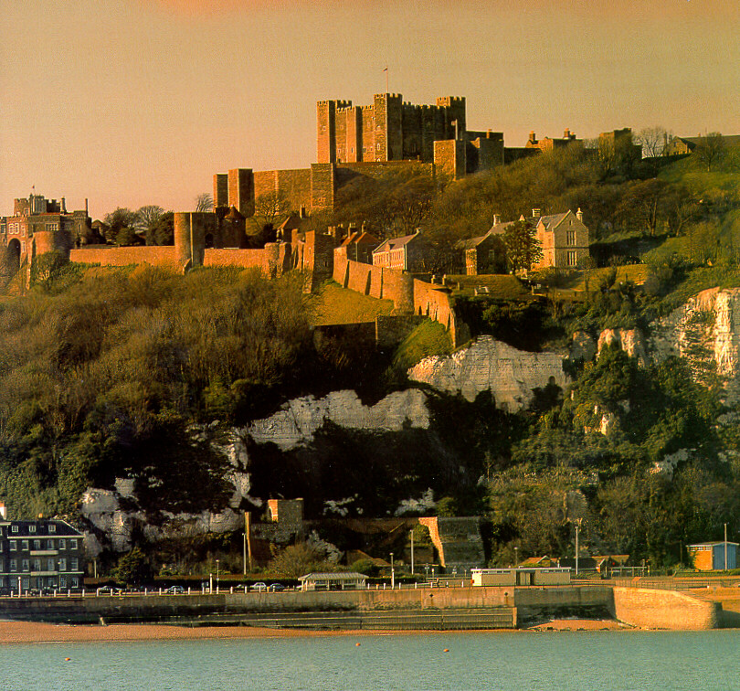
Above: A picturesque view of Dover Castle.
Jonathan Coad writes: "Dover Castle, one of the mightiest fortresses
in western Europe, guards the English end of the shortest sea
crossing to the Continent.
Its location, overlooking the Straits of Dover, has given it immense
strategic importance and has ensured that it has played a prominent
part in national history.
Its shape was largely determined by a pre-existing Iron Age
hillfort, while within its walls stand a Roman lighthouse and an
Anglo-Saxon church, the latter probably once forming part of an
Anglo-Saxon burgh or fortified town.
"There has been a castle here since November 1066.
That month, Duke William of Normandy's forces, fresh from victory at
the Battle of Hastings, constructed the first earthwork castle
before continuing their march on London.
The castle was to retain a garrison until October 1958 -- an
892-year span equalled only by the Tower of London and Windsor
Castle.
"During its medieval heyday this was very much a frontier fortress,
looking across to the frequently hostile lands of the counts of
Flanders and the kings of France.
Under Henry II the castle was rebuilt, incorporating concentric
defences and regularly spaced wall towers, a combination then
without parallel in western Europe.
In 1216 it successfully withstood a prolonged siege.
By the 1250s its medieval defences had assumed the extent and shape
which they retain to this day and the castle, on its cliff-top site,
formed a highly visible symbol of English royal power.
"After declining in importance from the sixteenth century, the
castle was modernised and its defences extended in the 1750s and
again during the Napoleonic Wars.
Further alterations and additional gun batteries added in the 1870s
enabled the castle to retain the role of First-Class Fortress almost
until the end of the nineteenth century.
"During both world wars the castle was rearmed, but perhaps its
finest hour came in May 1940.
In that month Vice-Admiral Bertram Ramsay, in naval headquarters
deep in the cliff, organised and directed the successful evacuation
of the British army from Dunkirk.
These same tunnels became in the 1960s a Regional Seat of Government
in the event of nuclear war; only in 1984 were they finally
abandoned."
Further quotes are from Dover Castle, the English Heritage
guidebook.
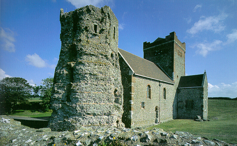
Above: Roman lighthouse and Saxon church
"At the highest point in the castle stand two buildings which
predate the castle -- the remains of a Roman lighthouse and a Saxon
church.
The surrounding bank dates from the thirteenth century but underlies
one dated by archaeologists to the mid-eleventh century, suggesting
that this area could be the site of the first small castle built by
William the Conqueror.
"In the second half of the first century AD the Romans began to
develop Dover as a port.
To guide ships across the Channel they constructed three
lighthouses.
One, the Tour d'Odre, stood at Boulogne; the other two were at
Dover, on high ground on either side of the small harbour.
The foundations of the western lighthouse can be seen at Drop
Redoubt on Western Heights on the far side of the town, while the
eastern one still stands within the later castle, where it forms one
of the most remarkable surviving structures of Roman Britain.
"The Roman pharos or lighthouse was originally an octagonal
tower with eight stepped stages, of which only four survive.
It rose to a height of some 24 m (80 ft).
Within its rectangular interior were a series of timber floors; at
the top there was probably a platform for some form of brazier.
After its abandonment by the Romans the tower became ruinous.
Later its exterior was refaced, and between 1415 and 1437 the top
was rebuilt as a bell-tower for the neighbouring church by Humphrey,
Duke of Gloucester.
"Adjacent to the lighthouse stands the church of St Mary-in-Castro.
Despite heavy restoration in the nineteenth century, it remains the
finest late Saxon building in Kent, dating from around AD 1000.
Its location, and the evidence of numerous Saxon burials found in a
graveyard to its south, suggest that there was a pre-Conquest
civilian settlement here.
The church probably originally formed part of an Anglo-Saxon
burgh, a fortified town within the Iron Age ramparts.
The builders made extensive use of Roman tiles and the church
retains its Saxon cruciform (cross-shaped) plan.
Certain details in the interior, such as the vaults in the chancel
and over the crossing, and the chancel windows, show that the church
was modified in around 1200, probably by the same masons who had
worked on the chapels in the keep.
"By the early eighteenth century the church was in ruins.
During the Napoleonic Wars (1803-15) it was used as a Fives Court
and then as the garrison coal store.
In 1862 it was restored by the architect Sir George Gilbert Scott
and in 1888 William Butterfield completed the tower and added the
unsympathetic mosaic decoration to the nave.
The nearby church hall forms part of this mid-Victorian renaissance
of this part of the castle; initially it was the schoolroom for the
children of the garrison.
"The surrounding medieval bank provides fine views.
It was once topped by a medieval curtain wall linking to the eastern
outer defences near Pencester's Tower and running westwards to
Peverell's Tower via Colton's Gateway.
The wall was demolished in 1772 but Colton's Gateway, built by King
John, and the length of curtain wall beyond it, give an impression
of the height of the missing sections.
Beside the church hall are the earthworks of Four-Gun Battery,
constructed in 1756."
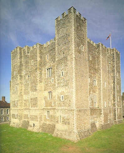
Above: Henry II's keep
"In the 1170s and 1180s, Henry II's military engineer Maurice was to
transform Dover.
Central to the great rebuilding was the massive new keep, which
ultimately was to be surrounded by a double ring of defensive walls,
making Dover the first concentric medieval fortification in western
Europe.
The keep itself served multiple functions as a great storeroom,
occasional residence of the monarch and his court, and ultimate
stronghold during a siege.
With few intervals and modifications, it was to retain a varied
military role up to 1945.
"The first line of defence beyond the keep were the curtain walls
and towers of the inner bailey, with its two strongly defended
gateways.
Within the courtyard a succession of buildings was later added for
royal and garrison use.
Today the inner bailey is lined with barracks constructed in the
mid-eighteenth century, but many of these incorporate the remains of
earlier medieval structures."
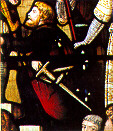
Above: Hubert de Burgh, in a Victorian painted window at
Dover Town Hall
"Hubert de Burgh was an able and efficient administrator and a
courageous soldier who had a long and distinguished career serving
Kings Richard I, John and Henry III.
In 1204 he gained fame through his prolonged defence of Chinon
Castle during John's retreat from Normandy, an experience that
undoubtedly helped him during the great siege of Dover in 1216-17.
In 1215 he was appointed Justiciar (chief minister) to the king, but
in the 1230s powerful opposition, and loss of the king's support,
led to his sudden downfall.
He died in 1243."
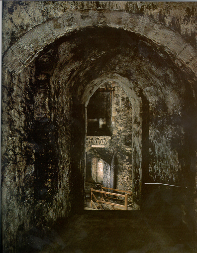
Above: The medieval tunnels
"The medieval underground tunnels at the northern tip of the castle
form part of an extraordinary defensive system constructed by Hubert
de Burgh after the siege of 1216.
His was the first of several attempts to strengthen this area of the
castle.
Hubert's new defences were substantially modified in the eighteenth
century, but the core of his underground work remains.
The tunnels were designed to provide a protected line of
communication for the soldiers manning the northern outworks, and to
allow the garrison to gather unseen before launching a surprise
sortie.
Later, during the Napoleonic Wars, the tunnels were largely
remodelled along with the outer defences, and were further
modernised in the 1850s.
In their date and complexity these tunnels are unique.
Access to them is down a spiral stair beneath the bridge leading
north from King's Gate barbican."
Above: The battlements walk
"Henry II's rebuilding campaign, begun in the 1180s and completed by
his successors Kings John and Henry III, made Dover Castle one of
the most powerful of all medieval castles.
This great strength was due to the successive layers or rings of
defensive walls protecting the keep in the centre.
This is the earliest use of such concentric defences on a castle in
western Europe.
These fortifications were to be augmented by artillery outworks in
the eighteenth and nineteenth centuries, most notably during the
1790s when attack by France was widely expected.
The Battlements Walk follows the outer line of the medieval
fortifications and gives stunning views over the castle's defences
and surrounding areas."
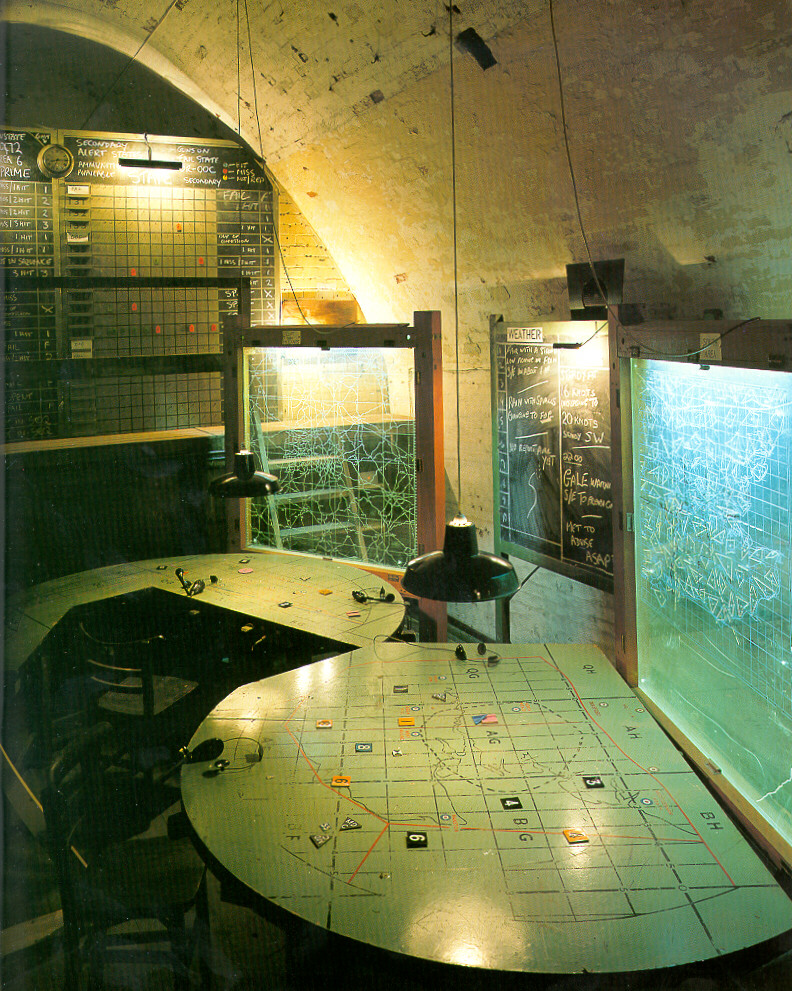
Above: (No longer) Secret Wartime Tunnels.
"The Secret Wartime Tunnels are a complex web of underground
rooms and passages which played a key role during the Second World
War.
They were later adapted to form the headquarters of one of a number
of Regional Seats of Government, secure accommodation to be used in
the event of a nuclear attack on Great Britain.
However, the first tunnels here are considerably older and were
built for a very different purpose [defense against France in the
late 18th century]....
"The three main headquarters within the tunnels at the outbreak of
the Second World War were the naval headquarters for the Dover
Command, the Coastal Artillery operations room and the anti-aircraft
operations room.
This last has been partly reassembled, again making use of
contemporary equipment.
"By contrast, Admiral Ramsey's former naval headquarters today
stands empty, enabling visitors to appreciate the huge scale of the
Georgian underground barracks.
In the walls are fireplaces which once provided some warmth for
George III's troops quartered here, while lines on the walls and on
the timber floor installed in the late 1930s show where naval office
partitions were located.
During the war years this tunnel was a warren of offices, with the
Admiral's own quarters in the cliff front overlooking Dover Harbour
and the Straights.
(The cliff end was sealed by the Home Office in the 1960s.)
Although it is silent now, little effort of imagination is needed to
visualise this once-busy hub of naval activity, scene of so many
momentous decisions.
"The hospital tunnels, known as Annexe Level, lie above and slightly
to the rear of the Casemate Level tunnels.
The main entrance links directly to an ambulance lay-by on the road
running up from Canon's Gateway.
Inside, the differences in plan, scale and construction between the
two sets of tunnels are at once apparent.
The main tunnels of the 1790s are lofty, spacious chambers, lined
with brick.
Their 1941 equivalents are far more cramped and are lined with steel
shuttering.
In addition the hospital tunnels, unlike their Georgian
predecessors, are laid out on a regular grid pattern.
"The hospital comprised a carefully planned sequence of reception
areas, wards, washrooms and latrines, galley and food store, and
operating theatres.
Most of the equipment on display is contemporary.
The operating theatre, galley and mess are based on photographs
showing them in use towards the end of the Second World War.
Casualties mercifully were far lower than anticipated and, as a
result, some of the tunnel wards were later given over to
dormitories and mess accommodation for military personnel based at
the castle."
Back to Hastings/Battle
Advance to London
Return to places page
Return to home page
|